Gallery of Good and Bad Days
Historical images of Phoenix Visibility Web Camera data have been selected to
visually depict the range of Visibility Index categories, seasonal conditions,
layered haze, and other unique events.
Site-specific galleries can be accessed by selecting the site of interest below.
Features for each site-specific image gallery include:
- Image spectrums consisting of a series of excellent to very poor regional haze conditions.
- Seasonal images representative of pristine, scenic, or meteorological interest.
- Unique representations of layered haze, regional haze, or pollution episodes of significant importance.
Individual images can be downloaded (saved) to your local hard drive by right-clicking the image and Save As file type of your choice. For more air quality information contact us at Arizona Department of Environmental Quality (ADEQ).
Unique Event galleries depict unique pollution episodes or meteorological events that represent air quality conditions from one or more scenic urban or rural vistas in the Phoenix, Arizona region.
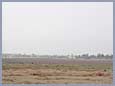
Dust Storm – May 2003
Strong sustained winds produced significant amounts of blowing dust in April and May of 2003. The following views from the Camelback Mountain and South Mountains Web cameras represent two days during the observed May 16 through 24, 2003 period.
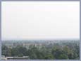
May 22, 2003
-
 Camelback Mountain viewing 42° Northeast at 9:15 a.m.
-
 South Mountain viewing 183° South at 9:15 a.m.
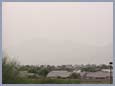
May 23, 2003
-
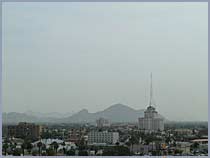
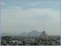 Camelback Mountain viewing 42° Northeast at 9:15 a.m.
-
 South Mountain viewing 183° South at 9:15 a.m.
Southern California Wildfires – October 2003
In October of 2003, Southern California experienced the most devastating wildland fire disaster in state history. Over 750,000 acres burned. Smoke from the wildfires caused unhealthy levels of particulate pollution in a large expanse of Southern California and the Southwestern United States.
Visibility in the Phoenix region was noticeably impacted from October 26 through November 9, 2003. The following images depict visibility conditions for each of the Phoenix.net Web cameras on the morning of October 30, 2003.
October 30, 2003
-
 Superstition Mountains viewing 90° East at 9:30 a.m.
-
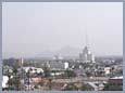 Camelback Mountain viewing 42° Northeast at 10:00 a.m.
-
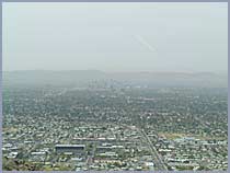
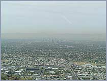
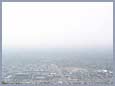 South Mountain viewing 183° South at 10:00 a.m.
-
 Estrella Mountains viewing 180° South at 7:15 a.m.
-
 White Tank Mountains viewing 274° West at 15:15 p.m.
Urban Fire Smoke Impacts
December 28, 2003
-
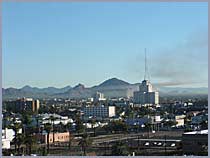 View of a structure fire (42 ° Northeast) from the Camelback Mountain Web camera, 8:30 a.m.