About These Data
VISIBILITY:
Visibility monitoring provides a measure
of how far and how well an observer can see through the atmosphere. Visual
range conditions are calculated
using air quality measurement data gathered by air quality monitors.
Light extinction is
defined as the loss of light due to scattering and
absorption as it passes through the atmosphere.
For this Phoenix region
application, the scattering component
of extinction is measured by an instrument (nephelometer) that
captures small amounts of air at a fixed location. Measurements taken by
this instrument can be affected by weather, especially in foggy or rainy
conditions.
METEOROLOGY:
Relative Humidity: The ratio of water vapor
in ambient air compared to the maximum amount of water vapor that could
occur at the ambient
air temperature.
The ratio is measured as a percent.
Temperature: The ambient air temperature
measured in degrees Fahrenheit and Celsius.
|
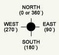
Wind Direction: Wind direction
is the direction from which the wind is blowing. It is measured
using a compass scale of 0 to 360 degrees. North is 0 or 360 degrees;
east is 90 degrees; south is 180 degrees; and west is 270 degrees.
See diagram.
|
 |
|
For example: a wind direction of 90 degrees describes
wind blowing from the east.
|
| |
Wind Speed: Wind velocity measured in miles per
hour.
REAL-TIME DATA DISCLAIMER
All data posted on the 48-hour data record page
are raw data. They have not been validated by human review and may
contain errors. Real-time
data must be interpreted with caution. These data are provided for
public
awareness
and Land Manager review only. They should not be used in any medical
or scientific study. Contact the Arizona Department of Environmental
Quality
to obtain quality-assured data summaries or access to fully-validated
data.