Camelback Mountain Gallery
To secure a representative gallery of observed air quality conditions for each scene monitoring site, a series of images are selected from the period of record and archived in several resolutions as an Image Gallery set.
The series of images making up the historical image gallery typically consists of:
The Camelback Mountain image gallery was last updated in May 2004. Check this page again for future updates.
Image Spectrum
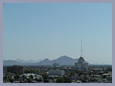
The following images have been selected to represent regional haze conditions corresponding to the Excellent to Very Poor categories of the Visibility Index Scale.
-
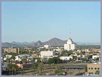
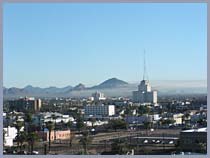
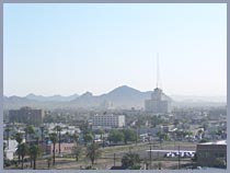
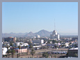
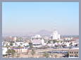
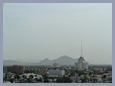
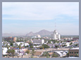
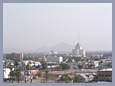
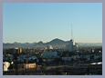
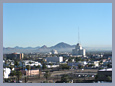
Excellent
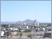 A clean March day with excellent visibility throughout the Phoenix monitoring region.
-
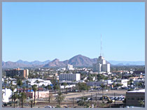
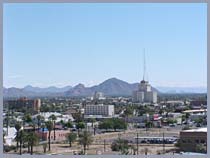
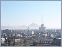
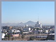
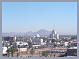
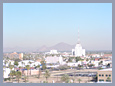
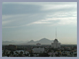
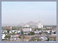
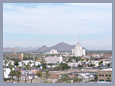
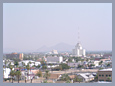
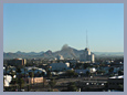
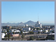
Good
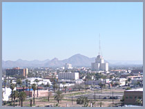 Typical good visibility day in March with a slight milky appearance of regional haze over the Camelback Mountain monitoring vista.
-
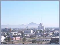
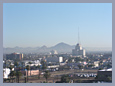
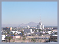
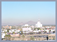
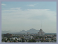
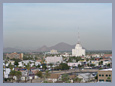
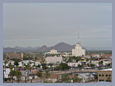
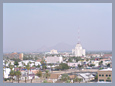
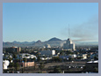
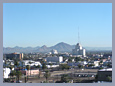
Fair
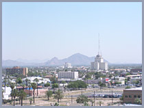 Typical fair visibility day in April with a moderate appearance of regional haze over the Camelback Mountain monitoring vista.
-
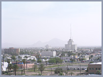
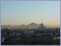
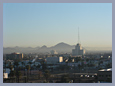
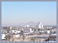
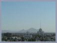
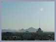
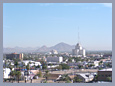
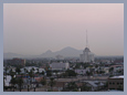
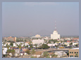
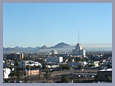
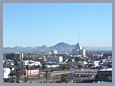
Poor
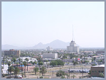 Poor visibility day in April with significant enough regional haze throughout the Camelback Mountain monitoring vista that Saddleback Mountain (23 miles) is no longer visible.
-
Very Poor
 Very Poor visibility day in March with significant regional haze throughout the Camelback Mountain monitoring vista that Camelback Mountain (8.4 miles) is barely visible.
Seasonal Images
The following images are representative of pristine, scenic, or meteorological observances of interest.
-
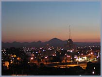
Pristine
December 16, 2003, 10:30 a.m.
Example of excellent visibility representative of the Camelback Mountain monitoring vista.
-
Scenic
October 1, 2003, 6:30 a.m.
Example of a typical morning skyline for the Camelback Mountain monitoring vista.
-
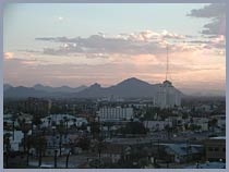
Scenic
October 10, 2003, 5:45 p.m.
Example of a typical evening skyline for the Camelback Mountain monitoring vista.
-
Scenic
October 11, 2003, 6:00 a.m.
Example of a typical morning skyline for the Camelback Mountain monitoring vista.
-
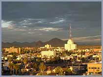
Scenic
March 29, 2004, 5:45 p.m.
Example of excellent visibility representative of the Camelback Mountain monitoring vista.
-
Scenic
April 23, 2004, 10:00 a.m.
Example of excellent visibility representative of the Camelback Mountain monitoring vista.
-
Meteorological Significance
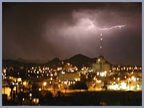
July 23, 2003, 3:00 a.m.
Unique example of lightning observed from the Camelback Mountain monitoring vista.
Unique Camelback Mountain Gallery Images
The following images are representative of observed layered haze, regional haze, or pollution episodes of significant importance.
-
Layered Haze
December 28, 2003, 8:45 a.m
View of urban fire plume impacting the Phoenix metro region, as seen from the Camelback Mountain monitoring vista, viewing 42° northeast.
-
Layered Haze
January 29, 2004, 7:45 a.m.
Representative ground-based and elevated layered haze impacting the Phoenix metro region, as seen from the Camelback Mountain monitoring vista.
-
Layered Haze
March 7, 2004, 8:00 a.m.
Regional haze event and ground-based layered haze that could be observed from several Phoenix visibility Web cameras. Camelback Mountain monitoring vista viewing 42° northeast.
-
Layered Haze
March 7, 2004, 9:30 a.m.
Regional haze event and ground-based layered haze that could be observed from several Phoenix visibility Web cameras. Camelback Mountain monitoring vista viewing 42° northeast.
-
Layered Haze
March 29, 2004, 8:00 a.m.
Representative ground-based layered haze impacting the Phoenix metro region, as seen from the Camelback Mountain monitoring vista.
Regional Haze
January 29, 2004
Representative regional haze event that impacted visibility, as seen from the Camelback Mountain monitoring vista.
-
 8:00 a.m.
-
 9:00 a.m.
-
 9:30 a.m.
-
 10:00 a.m.
-
 11:00 a.m.
-
 12:00 p.m.
-
 1:00 p.m.
-
 2:00 p.m.
-
 3:00 p.m.
-
 4:00 p.m.
A representative regional haze
event occurred January 29 through 30, 2004 that could be seen
from several Phoenix visibility Web cameras. Hourly interval
Images depicting January 29, 2004 visibility as seen from
the Camelback Mountain monitoring vista are shown above.
Pollution Episode
May 16 through May 24, 2003
Dust Storm Event as Seen from the Camelback Mountain Monitoring Vista.
-
 May 16, 2003,
9:15 a.m.
-
 May 18, 2003,
9:15 a.m.
-
 May 19, 2003,
9:15 a.m.
-
 May 20, 2003,
7:15 a.m.
-
 May 20, 2003,
9:15 a.m.
-
 May 21, 2003,
7:15 a.m.
-
 May 21, 2003,
9:15 a.m.
-
 May 22, 2003,
7:15 a.m.
-
 May 22, 2003,
9:15 a.m.
-
 May 23, 2003,
7:15 a.m.
-
 May 23, 2003,
9:15 a.m.
-
 May 24, 2003,
7:15 a.m.
-
 May 24, 2003,
9:15 a.m.
Strong sustained winds produced
significant amounts of blowing dust in April and May of 2003.
The above views from the Camelback Mountain Web camera depict
fair to poor visibility conditions during the May 16 through
24, 2003 period.
Pollution Episode
October 26 through November 9, 2003
Southern California Wildfire Impacts as Seen from the Camelback Mountain Monitoring Vista.
In October of 2003, Southern California experienced the most
devastating wildland fire disaster in state history. Over
750,000 acres burned. Smoke from the wildfires caused unhealthy
levels of particulate pollution in a large expanse of Southern
California and the Southwestern United States. Visibility
in the Phoenix region was noticeably impacted from October
26 through November 9, 2003.
Below are selected hourly images depicting visibility conditions
observed from the Camelback Mountain Web camera from October
28 through October 30, 2003.
-
 October 28, 2003,
2:00 p.m.
-
 October 28, 2003,
4:00 p.m.
-
 October 29, 2003,
7:00 a.m.
-
 October 29, 2003,
10:00 a.m.
-
 October 29, 2003,
12:00 p.m.
-
 October 29, 2003,
2:00 p.m.
-
 October 29, 2003,
4:00 p.m.
-
 October 30, 2003,
7:00 a.m.
-
 October 30, 2003,
10:00 a.m.
-
 October 30, 2003,
2:00 p.m.
-
 October 30, 2003,
10:00 a.m.
-
 October 30, 2003,
4:00 p.m.
Pollution Episode
December 28, 2003
Urban Fire Event as Seen from the Camelback Mountain Monitoring Vista.
-
 8:10 a.m.
-
 8:05 a.m.
-
 8:30 a.m.
-
 8:45 a.m.
-
 9:00 a.m.
-
 9:15 a.m.
-
 9:30 a.m.
-
 9:45 a.m.
Fifteen-minute interval images depicting unique
structure fire plume(s) and plume dispersement are shown above.
All images were observed from the Camelback Mountain Web camera
viewing 42° northeast.